Multi-fold GPR and magnetic gradiometry for ultra high resolution study of archaeological sites
Michele Pipan, Luca Baradello, Emanuele Forte, Alessandro Prizzon, Icilio Finetti
(2nd International Congress Science and Technology for the safeguard of cultural heritage in the mediterranean basin Paris, 1999)
Abstract
Introduction
Multi-Fold GPR images subsurface features at depths ranging between few
centimetres and 20-30 metres (in resistive materials) with the highest degree of
vertical and horizontal resolution allowed by non-invasive techniques. The
productivity of the method is rather low and this is a major drawback,
particularly in the study of vast and poorly known areas. Magnetic gradiometry
is an ideal complement to multi-fold GPR since it allows
rapid surveys over large areas, it is not sensitive to temporal
variations of the magnetic field and it provides high resolution discrimination
between neighbouring anomalies also in the case of low susceptibility contrasts.
The integrated use of these
techniques gives the following benefits:
-
Acquisition grids and parameters are rapidly optimized through the analysis of
exploratory GPR profiles and magnetic grids
-
Magnetic
and GPR data can be jointly inverted to obtain well constrained high resolution
subsurface images
-
The
solution is cost effective because MF GPR can be focussed on the areas of major
potential interest identified from the preliminary magnetic surveys.
On the
other hand, the sensitivity of the two techniques to different parameters
(magnetic susceptibility/remanent magnetization, conductivity, relative
permittivity) prevents from using either of them, at least where magnetic and
electric characteristics of the targets are not sufficiently known and constant
over the area of study.
We carried
out a combined GPR and magnetic gradiometry survey in the Archaeological Park of
Aquileia (Italy)
during 1998 in the framework of a scientific cooperation among the Exploration
Geophysics Group of the University of Trieste, archaeological research groups of
the University of Trieste and the local Superintendency of Cultural Heritage.
The
primary objective was the study of a 6 sq kilometres area located on top of a
moderately elevated hill (maximum elevation 4 m) named
Beligna High.
The area, which is scheduled for roadworks in 2000, was known from historical
documents as the location of the San Martino Abbey, erected around A.D. 485 on
the site of a paleo-Christian cemetery, and razed to the ground around the
beginning of the 18th century. A precise location of the abbey is
missing and the application of non-invasive geophysical techniques was therefore
planned out to obtain information about the area, primarily including position,
dimensions and nature of buried features of potential archaeological interest. A
further objective of the study was the test of combined GPR and magnetic methods
as a cost effective solution for the study of archaeological sites.
GPR was
selected for the following reasons:
Expected target depth (not greater than 4 m) and characteristics
(sand/limestone, sand/bricks, sand/compacted stone debris
contacts)
Demand for high vertical and horizontal resolution
Demand for rapid data acquisition and processing
Magnetic
gradiometry was employed as a preliminary survey technique to focus the
application of the costlier GPR on the sites of major interest. It was expected
to provide results particularly as far as brick walls and foundations were
concerned.
The
geophysical survey tackled the following objectives:
1. The
identification of floors, foundations, ruined walls essentially made of
limestone or bricks at depths ranging between 50 cm and four meters in sandy
sediments.
2.
Mapping of features of possible archaeological interest located at depths not
exceeding four meters.
3. Test
of integrated magnetic and GPR techniques to analyse correlations among observed
anomalies and to evaluate the effectiveness of their combined use in
archaeological studies.
The area
of study
Aquileia
is one of the most important archaeological sites in northern Italy and it was a
rich roman town during the imperial period, with a maximum population of more
than 200.000 inhabitants. A prominent commercial centre that connected the
central and northern Europe with the Mediterranean area, Aquileia was first
razed to the ground by Attila in the V century and successively abandoned for
approximately 250 years before the beginning of the IX century. During this
period the whole area changed into a marsh due to an uncontrolled water supply
from previously canalized streams and springs. A layer of sediments of variable
grain size (from sands to pelites) and average thickness not less than 100 cm
deposited during this period. The layer is substantially preserved in wide
sectors of the Aquileia archaeological park as the town never reached the
extension of the imperial period again. However, intense agricultural and
construction activities as well as large projects, such as a diversion or
canalization of part of the main tributaries to the neighbouring lagoon, deeply
modified the area and extensively reworked the sediment layer that protects the
roman remains. The area is characterized by facies of alluvial plain with large
marshy sectors evidenced by peat clays with fresh water faunas.
Equipment
and data acquisition
GPR
equipment and single-fold data acquisition
We used a
RAMAC digital GPR equipped with 100 MHz, 200 MHz and 400 MHz antennas. A high
amplitude pulse (1000 V) was fed to the antenna element. The raw GPR data were
stored in 16 bit binary format on a portable PC. We used a wooden framework to
space out transmitter and receiver and speed up multiple common offset data
acquisition. Proprietary software of the Exploration Geophysics Group and RADPRO
software of Malå
Geoscience were used for quality control during data acquisition.
Single
fold profiles were first shot with the following objectives:
1.
Preliminary identification of the targets
2.
Calibration of the instrument
3.
Selection of the optimum frequency (antenna)
4.
Analysis of the subsurface response as a function of the orientation of
the profile
GPR
multi-fold data acquisition
The
following multifold acquisition schemes were then used to study the areas where
potential targets or significant anomalies in the radar response had been
identified in the field by means of preliminary quality control:
-
Common
Mid Point (CMP) gather
-
Multi-Azimuth Common Mid Point (MA-CMP) gather
-
Common
Source gather (end on geometry)
-
Common
Offset Sections
A 2-D
multi-fold grid was completed
to
map dimension and orientation of the anomalies of potential interest. A maximum
offset of 250 cm was used (200 MHz). The average maximum offset was 180 cm.
Magnetic
gradiometry equipment, data acquisition and processing
We used a
Geometrics G858 cesium vapor gradiometer to collect 4141 data points on a 40 x
100 metres grid which covers part of the area successively surveyed by GPR.
Sensors were 100 cm apart with lower sensor located 50 cm above the ground. The
acquisition of the whole grid was repeated five times to check the stability of
the measurement and the final value at each grid point was obtained from the
average of the 5 data value. Maximum variations of the vertical gradient as
small as 0.04 nT were obtained from the different acquisitions. The data were
filtered to remove spikes and long wavelength anomalies.
GPR data
processing
General
remarks and flow-chart
Common
Source (CS) and Common Mid Point (CMP) records helped discriminate signals of
interest from noise components and select the optimum offset for single-fold
data acquisition. Large cobbles at shallow depth are the main source of noise in
most cases and show up as linear or (skewed) hyperbolic signals in CS and CMP
records. CMP records were further exploited
to calculate radar waves propagation velocities, of use to provide
migrated and depth converted interpreted section to the archeologists.
The
following sequence was applied for the complete processing of the data:
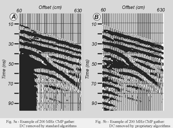
DC component removal
Time-zero drift correction
Amplitude analysis
Spectral analysis
Spherical divergence correction
Design and application of Band Pass filter
Velocity Analysis
Azimuthal Velocity Analysis
Velocity analysis of GPR data are normally performed on CMP gathers. We have performed multi-fold data acquisition along different azimuths at selected points of the acquisition grid. In this way we can analyse radar velocity variations which basically depend on the dip of the subsurface discontinuity. There is a more interesting effect on velocities associated with targets characteristic of archaeological sites, i.e. narrow and elongated features such as, e.g., walls and trenches flanking roads or utilized for irrigation in the past. Radar velocities measured across such targets are strongly dependent on azimuth when the contrast in dielectric constants is sufficiently large.
Shape detection based suppression of coherent noise (proprietary
algorithm)
Weighted stack
Post-stack time migration
Pre-stack gathers, stack sections and velocity analysis panels were interpreted to map the anomalies of potential interest.
The
original GPR stack profiles,
the migrated envelope amplitude and instantaneous phase sections calculated from
the same data
were used to analyse correlation between GPR reflectors observed in different
sectors of the area of study.
Results
The
eastern sector of the magnetic grid shows ENE-WSW anomaly alignments localized
at the northern and southern margin of the study area. GPR data obtained across
such anomalies show no evidences of discontinuities to approximately 350 cm
depth. This is particularly apparent at the northern margin where flat,
subhorizontal reflectors corresponding to the shallow sedimentary unconformities
are observed. The penetration of the radar signal to at least 350 cm is verified
in the sectors of the study area where reflectors at that depth are imaged. The
possible sources for such anomalies should be therefore located at greater
depths and they are probably out of the range of interest for the archaeological
objectives pursued in this study.
GPR clearly images three targets of major interest:
a.
A
sub-horizontal reflector, slightly inclined towards south, at an average 250 cm
depth is observed across an area of approximately 1200 sq metres.
b.
The
northern border of the flat reflector is a shallow, narrow (approximately 150 cm
wide), ENE-WSW elongated object at average 70 cm depth which produces a strong
diffraction in 4 GPR profiles.
c.
The
southern border of the flat reflector is a sharp steplike feature, parallel to
the northern border, which separates the flat, sub-horizontal 250 cm deep
reflector from a deeper one, located around 350-400 cm, which shows a more
pronounced dip to the south.
Scattered
diffractions are locally observed to the north in average conditions of flat
sedimentary layering of no interest from the archaeological point of view.
MF sections show the enhancement obtained from multi-fold techniques.
We have compared all the GPR profiles with the magnetic ones to locate possible correlations. The maximum and minimum value of the superimposed gradient are ±20 nT respectively and the relative vertical location of the magnetic data is such as to emphasize the correlations between GPR and magnetic data. A correlation exists in the leftmost sector of the profile, while a prominent diffraction which marks the northern border of the flat reflector in the radar profiles does not influence the magnetic profile at all.
Conclusions
The
analysis of the data obtained in the framework of this study and the comparison
with results validated by archaeological excavations from other sites in the
Aquileia Archaeological Park indicate that:
1.
Three
main features of archaeological interest are imaged by GPR:
a.
Reflector:
the strength of the reflection matches that of stone floors buried in the forum
area, where the composition of the soil is similar to that of the Beligna High.
b.
Northern
border:
comparison with datasets from other sites of the Archaeological Park shows that
the response has characteristics [amplitude, instantaneous attributes (envelope
and phase) and diffractions] identical with those obtained from buried walls at
depths ranging between 50 and 150 cm.
c.
Southern border:
the sharp, linear margin is consistent with the termination of a platform-like
buried structure.
![]()
2.
The integration of magnetic gradiometry and GPR is a cost effective
solution for rapid, high resolution surveys of sites of archaeological interest
but direct correlation of gradient anomalies and GPR profiles is not always
feasible, as demonstrated (e.g.) by the combined GPR and magnetic profile.
Actually, one of the targets of major archaeological interest in the area is not
correlated at all with the observed variations of the magnetic gradient.
3.
In the
study area magnetic gradiometry are apparently influenced by features deeper
than the range of GPR [with the only exception of very strong (i.e.>200nT)
anomalies of shallow and probably metallic origin] and therefore most probably
located in the proto- and pre-historic layers of limited interest from the
archaeological point of view. Such features may be related with materials
deposited in the paleochannels across the bar which forms the Beligna High,
whose orientation in the area of study is known from literature to be consistent
with that of the observed anomalies
4.
Multi-fold GPR provides the necessary information to migrate and depth convert
profiles as well as to enhance subsurface images. Moreover, the application of
azimuthal velocity analysis techniques allows a more reliable correlation of
anomalies across different profiles and the identification of elongated targets.
The high resolution GPR images may greatly simplify magnetic data processing in
case of correlation of magnetic and GPR anomalies. In this case, 2-D filters can
be used to remove noise and isolate short wavelengths for a preliminary
identification of the areas of interest from magnetic data, while GPR data can
be successively used for a precise vertical and lateral location of targets.
Acknowledgments