PROGETTO CAMI
Caratterizzazione dell'Acquifero con Metodologie Integrate
2002-2007
CAMI è un progetto pilota finanziato dall'Unione Europea nell'ambito del Programma LIFE.
OBIETTIVO
CAMI mira a sviluppare un pacchetto integrato di metodologie di riferimento basato su indagini geofisiche,
geochimiche e di monitoraggio a livello di bacino idrico, sviluppato nell'ambito della dir. 2000/60/CE.
Le disposizioni sulla protezione delle acque è trattata dalla direttiva 2000/60/CE (direttiva quadro in materia di acque).
E' la legislazione fondamentale per la protezione dell'ambiente acquatico europeo che:
fissa un quadro comunitario per la protezione delle acque superficiali interne, della acque di transizione, delle acque costiere e sotterranee
assicura la prevenzione e la riduzione dell'inquinamento
agevola l'utilizzo idrico sostenibile
protegge l'ambiente
migliora le condizioni degli ecosistemi acquatici
mitiga gli effetti delle inondazioni e della siccità
PARTNERS
Istituto Nazionale di Oceanografia e di Geofisica Sperimentale - OGS
Acque del Basso Livenza S.p.A. Servizi Idrici Interregionali
Dipartimento di Scienze Geologiche Ambientali e Marine Università degli Studi di Trieste
Università degli studi di Ferrara Dipartimento di Scienze della Terra
TNO
Eurekos S.R.L.
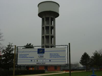
SITO: Torrate di Chions (pn)
MY CONTRIBUTION TO THE PROJECT: Acquisition, processing and interpretation GPR data. Acquisition seismic data.
ACQUISITION AND PROCESSING GPR
DATA
The GPR data were collected with a GSSI SIR2000 equipped with a 100 MHz
monostatic antenna.
I chose that frequency instead of other frequency (400, 200 and 75 MHz) because
field tests showed a good compromise between penetration and resolution.
In the study area we carried out 30 GPR parallel profiles, a total of 10 km, in
continuous data collection method. In this case one person trailed the radar
along the line at constant velocity (normal walking) and the antenna transmitted
32 pulses/second. Along the profiles we fixed the regular marks every 6 m.
In the pre-processing phase I made an interpolation of the data in X-direction
on the basis of markers stored into headers data obtaining a new regular
intertrace of 10 cm. The time-zero drift correction was calculated shotting the
pulse against an obstacle on air at different known distances.
The electromagnetic wave decays rapidly into this ground and to recover the
signal amplitude I applied first a spherical divergence then calculated the mean
decay curve of all traces and applied its inverse.
Finally a recursive Butterworth bandpass filter with frequency range depending
by depth was designed.
To estimate the mean velocities in these zero-offset profiles I applied two
methods: the hyperbola best fitting and F-K migration scan. For this soil we
average a radar velocity of 7-8 cm/ns.
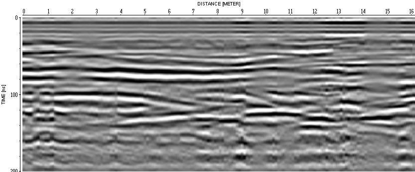
A section with standard processing (Gain and Butterworth filter).
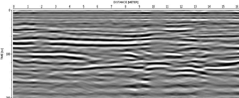
A Stolt migration with constant velocity about 7 cm/ns produces a good real section.
RESULTS
From the GPR section it's
possible to divide the study area in two characteristics type of subsurfaces:
A) Zones with a compact layer
B) Zones with no compact layer but a mix of different kinds of materials.
The first type is characterized by very low penetration and a lot of ringing.
It’s possible to attenuate the ringing noise with a 2D spatial filtering but the
sections after filter don’t have information about structures.
In the B zones the electromagnetic waves have a good penetration (until 200 ns)
and very complex structures are detected. Maybe this soil is a mix of different
clays with inside sand lends. Probably these irregular areas are potential
pathways for subsuperficial fresh water flux and springs.
Analyzing an old orthophoto made before the trees we can see zones with
different colour (dark shadows) reflecting wet materials. The GPR profiles
collected show concave reflections joined to these zones. These are ancient
depressions or natural channels filled with made ground.
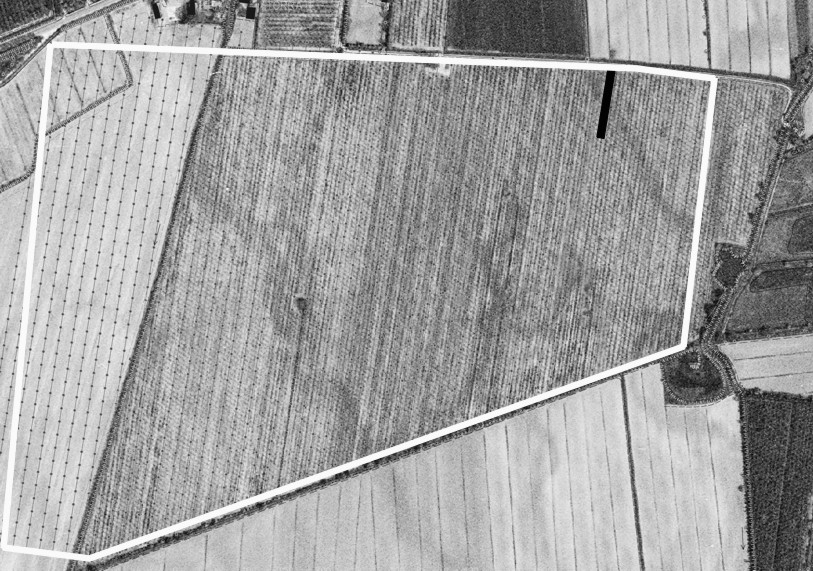
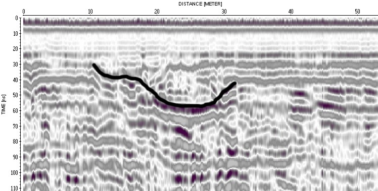
The white polygon in orthophoto is the GPR survey area. The dark shadows in the field are wet zones. The black line is a GPR profile. The concave reflection is located on a dark shadow: It's an ancient channal.